The Surprising Terminal Channels of Borrego Palm Canyon Creek
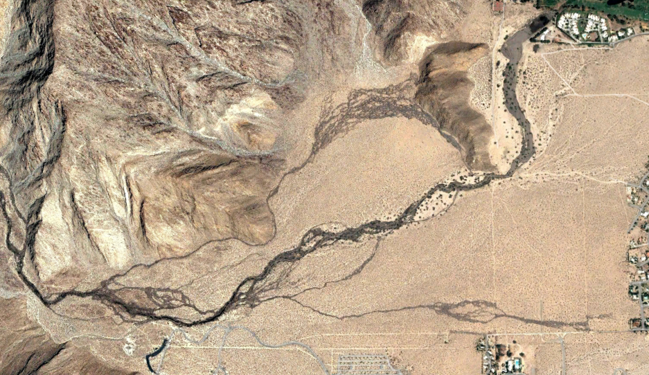
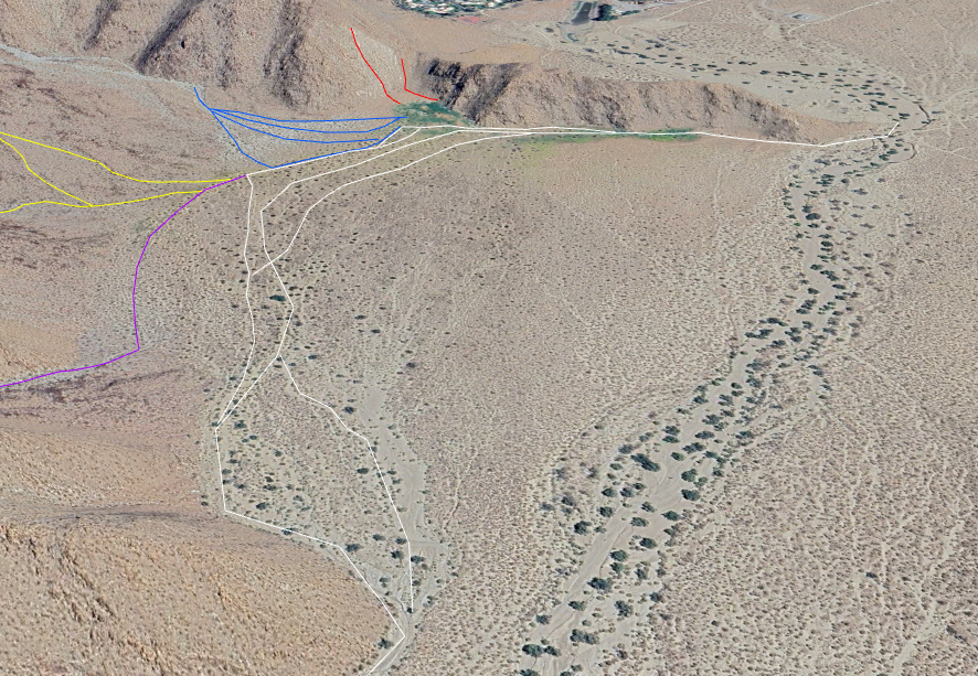
Fig. 1. Google Earth satellite view of the terminal channels of Borrego Palm Canyon Creek on 15 September 2003, 25 days after a ten-foot-high wall of water came barreling out of the mouth of Borrego Palm Canyon, and high water flows persisted for days. The meandering dark brown areas on the map on the desert floor show the mud and dirt deposited by flows in multiple braided channels of Borrego Palm Canyon Creek. We call the major channel to the north the "North channel", and the one to the south the "South channel". An "Overflow channel" is also labeled at the bottom of the photograph.
Two informal names are given in white in parentheses on the map. "The Cove" is the little valley that is cut into the San Ysidro Mountains, bordered on the east by "Little Baja". A portion of the grayish curved Borrego Palm Campground Road is visible just left of the bottom of the middle of the photograph. The De Anza Development is in the upper right corner of the photograph.
If you look at the USGS Topo Map, there is nothing unusual about the end of the Borrego Palm Canyon Creek. It leaves the mouth of Borrego Palm Canyon, heads roughly north east, and dies in the desert sand. We and others have watched the Creek ebb and flow over the last 20 years, sometimes with its last water absorbed in the Palm Grove, and sometimes flowing almost a mile into its alluvial fan before its water is fully absorbed by the sand in its channel.
But in 2016, we went just a bit farther downstream, and discovered an incised canyon of depth about ten feet that indicated major amounts of water had been coming from an area perpendicular to the flow of the Creek. This perplexed us until we looked at historic Google Earth Images such as the one shown in Fig. 1 that clearly showed there was significant water flow from Borrego Palm Canyon Creek taking an extended detour up into the little valley to the north! That little valley is called "The Cove" by some Borrego Springs residents, bordered on the east by what is called "Little Baja", from its shape on an aerial image.
The Google Earth image in Fig. 1 was taken on 15 September 2003, 25 days after a ten-foot-high wall of water came barreling out of the mouth of Borrego Palm Canyon. High water flows persisted for days. This was a result of extremely heavy rain on the desert side of the San Ysidro Mountains on 19-21 August, 2003. The remnants of Tropical Storm Erika, and combined with subtropical moisture from the Gulf of Mexico, produced thunderstorms that dumped a major amount of water in a short period of time. 4.7 inches of rain was recorded at a gauge in Ranchita from 19 to 28 August 2003. All that rain in the watershed of Borrego Palm Canyon produced the massive flow of water that emerged from the mouth of Borrego Palm Canyon that destroyed the bridge on the trail that crossed it.
Fig. 1 shows that the massive flow of water ended up in every channel available to it, despositing massive amounts of mud. The South Channel is the one shown on the topo map, and large volumes of dirt / mud were deposited along its entire length. Large amounts of water and mud also flowed into the north channel, which is a narrow channel that follows the base of San Ysidro Mountain at first, and then spreads out in its braided alluvial slope at the north end of The Cove.
Why would Borrego Palm Canyon Creek sometimes take the non-direct, meandering, 0.3 miles longer way of the North Channel? We think the answer is simply that the Cove is part of the Borrego Palm Canyon alluvial fan, and most creeks and rivers meander all over their alluvial fan. When they deposit too much material in one channel, the water gets diverted into another channel, or it makes another channel in the fan.
The 800 foot contour line shown in the topo map in Fig. 2 essentially outlines The Cove in its entirety, and goes right across the mouth of Borrego Palm Canyon. The lower contour lines make it clear that The Cove is just part of the BPC alluvial fan.
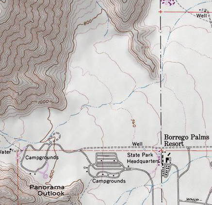
Fig. 2. Topo map of the alluvial fan area of Borrego Palm Canyon Creek.
But there is an added twist to the story here. Not many alluvial fans have mountainous terrain on one side of them that supply additional water flow to that side! That mountainous terrain drains into the North Channel. Flash floods from that terrain can help to deepen the North Channel, either on their own or by augmenting the flow from Borrego Palm Canyon Creek.
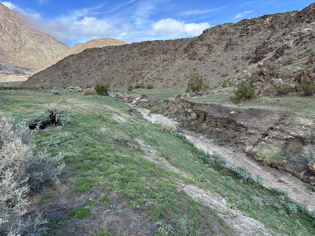
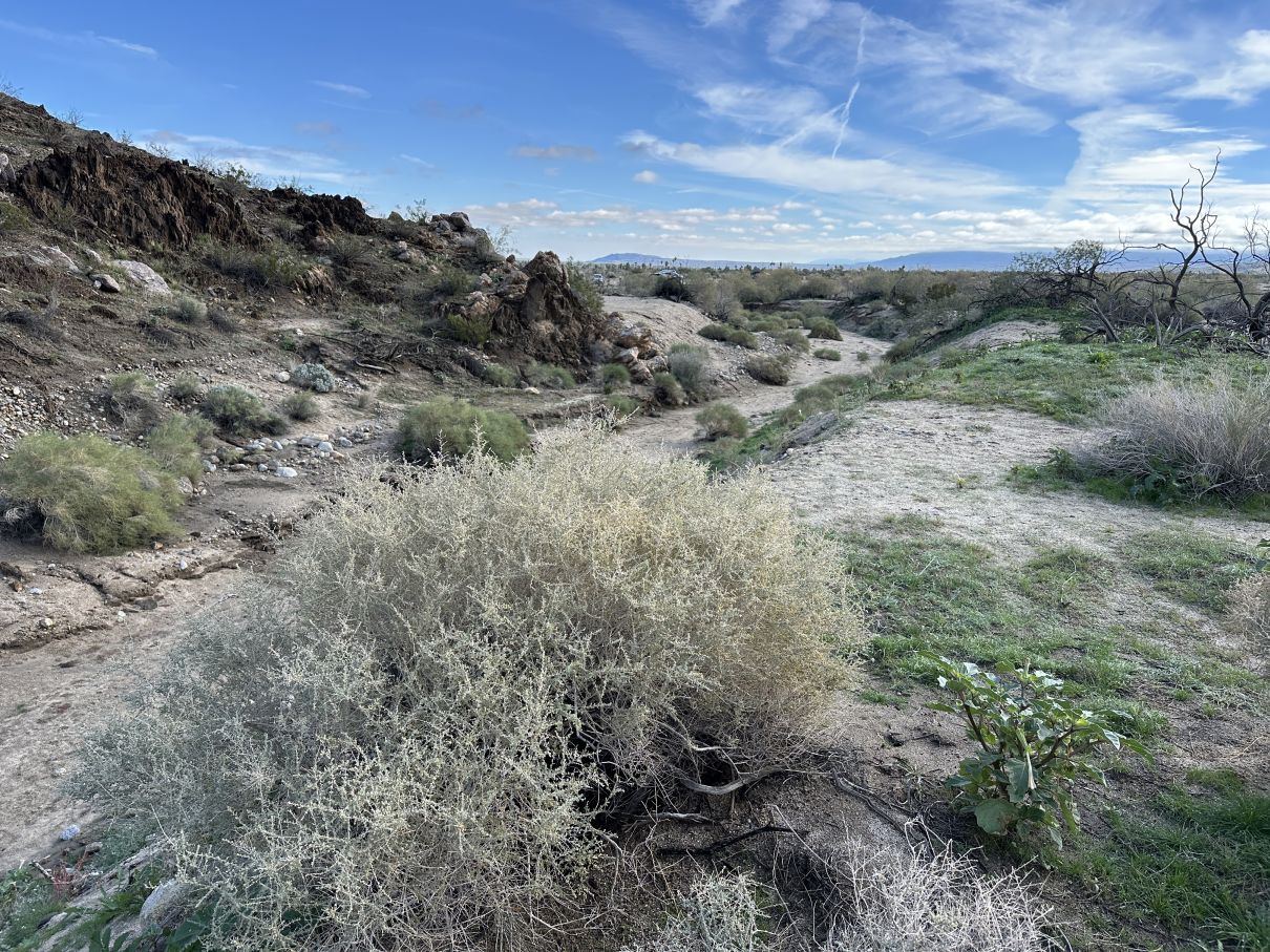
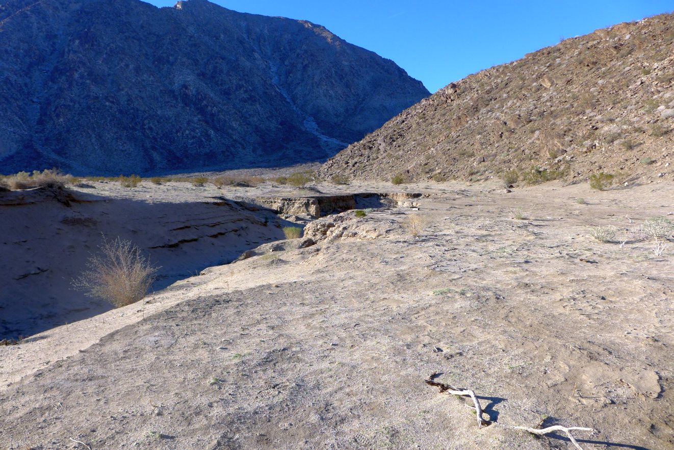
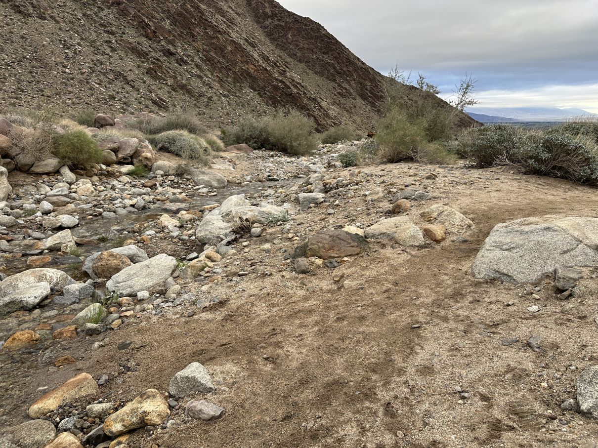
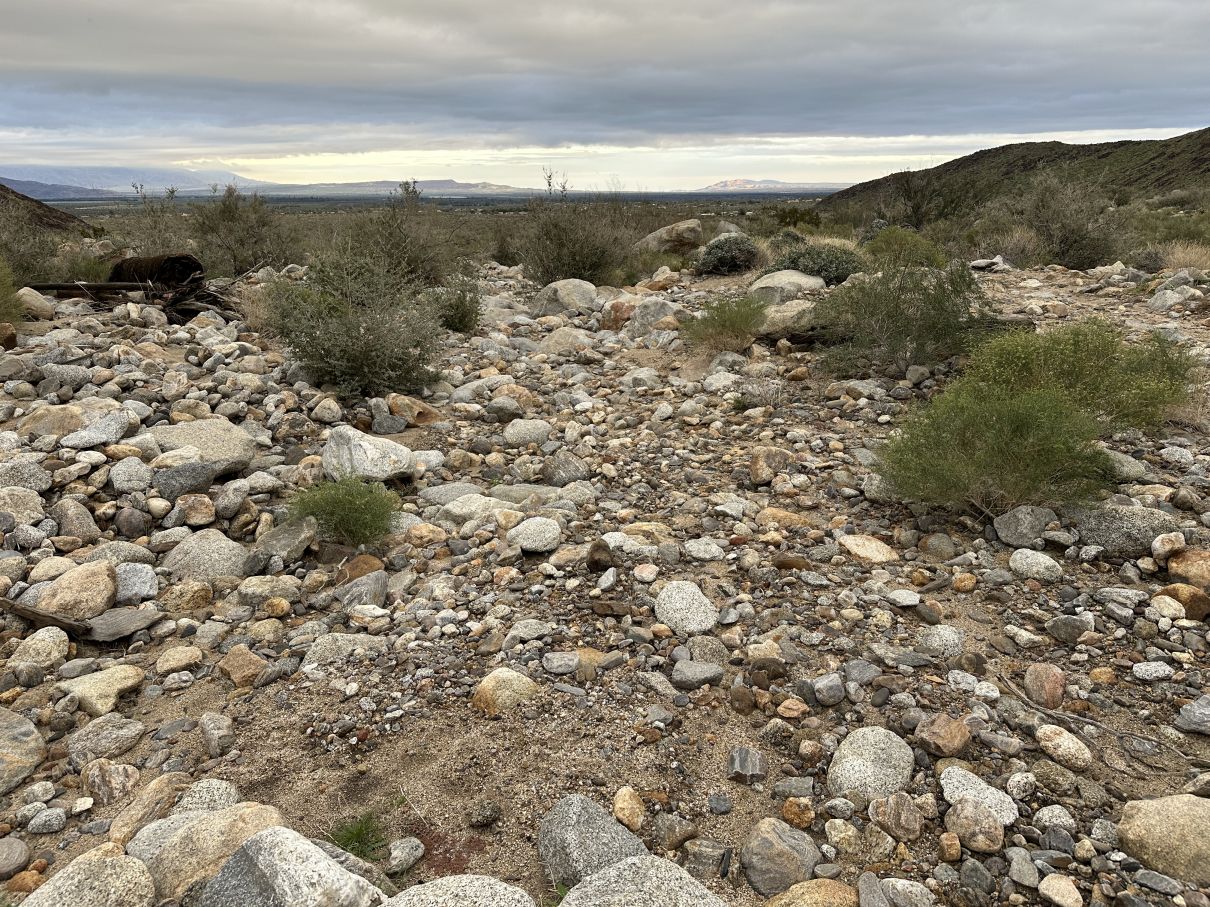
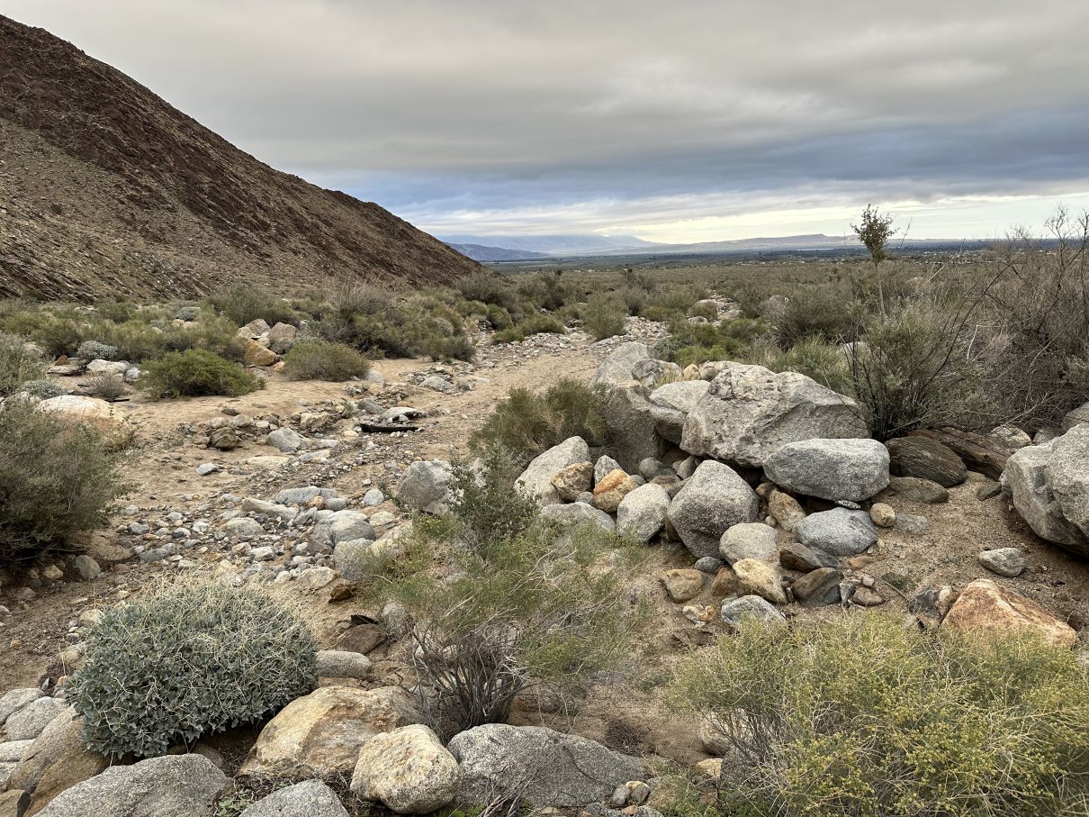
Fig. 3 shows the incised portion of the North Channel as of 2 January 2026.
| 
|
| Fig. 3. The incised terminal portion of the North Channel as of 2 January 2026. Left: View looking upstream, showing the incised portion running along the base of Little Baja. Right: View looking downstream, as the incised portion begins to round the southern end of Little Baja. The South Channel pours over the edge of the incised North Channel just left of the cars in the distance (best seen in the larger version of this pix).
Photos by Tom Chester. Click on the pictures for larger versions. | |
The incised portion of the North Channel has extended northward by ~30 m (100 feet) just since 2010! Google Earth historic images have enough resolution to clearly show the lip of the incision (=the "nick point") in 2010 and 2023, and have barely enough resolution to give a hint of the location of the lip of the incision in 1995. Fig. 4 shows where the lip of the incision was from those three dates.
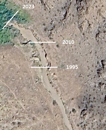
Fig. 4. Google Earth image of the incised portion of the North Channel, with white lines indicating where the lip of the incision was on three dates. The lines for 2023 and 2010 are precisely located, but the line for 1995 is just a "best guess" in the low-resolution image.
The lip of the incision has moved approximately 0.03 miles in 28 years, a rate of ~2 m / year (~6 feet / year).
It is quite uncertain to extrapolate the movement of the lip in the future, since it probably only moves during infrequent flash floods. There were at least two such events during this period. In addition to the 2003 flooding event, there was a "100 year flood" the very next year, in 2004, when a 5-10 foot tall, 100 feet wide wall of water was observed at the campground, coming out of the mouth of Borrego Palm Canyon. That flood took out a large number of palm trees (~80% of the individuals in the First Grove), leaving them scattered along the lower portions of the trail, and sometimes in stacks of three palm trees angled on top of each other. Many of the trunks were broken by the force of the water, and some palm tree trunks even ended up below large boulders!
Tom's photo from 26 January 2016 show the nick point at about the 2010 location in Fig. 4, compared to his photo from 2 January 2026 which show the nick point at about the 2023 location in Fig. 4. Although those linked photos were taken from different locations, you can match the rocks and creosote bushes in both pix. Also note that the incised channel below the nick point in 2016 appears to be heading toward (or away from) Little Baja, whereas the incised channel below the nick point in 2026 parallels the base of Little Baja, as shown in Fig. 4.
Tom took a repeat photo on 30 January 2026 from the same location as the photo from 26 January 2016, but most of the headward extension of the incised channel is not easily visible due to a single creosote bush that had grown remarkably in that period of ten years.
Clearly, this incision is a very recent occurrence. Such incisions in drainage channels in semi-arid areas started occurring in the southwestern U.S. a century or so ago. This process is called arroyo cutting, and is frequently caused by human disturbance in an area. One doesn't have to look far for the cause of the incision in the North channel. The de Anza Desert Country Club development immediately downstream was built in 1955 and 1956.
It appears from Google Earth images that as part of the development they excavated sand from a basin in the creek bed 0.4 miles downstream from the confluence of the North and South channels. Creeks have an equilibrium elevation profile along their length that depends on specific characteristics such as the elevations of their ends, and properties of the mediums through which they flow. If you drop their elevation at one point, they will produce a new equilibrium elevation profile by excavating their channel upstream from that disturbance. This is exactly what is happening here.
Google Earth shows a 20 foot drop in the creek bed in that excavated area, so it is not a surprise that there is a ten to 20 foot incision propagating upward. The current nick point is 0.6 miles upstream from the excavated area, implying a nick point retreat of 0.6 miles / 70 years = 0.009 miles / year = 14 m / year = 45 feet / year. This is a much larger, and much more accurate measure of the average retreat than the rate of 2 m / year based on approximate data over 28 years. It is also possible that the retreat of the nickpoint is now much smaller than it was originally, since the retreat is now only in the North channel, whereas initially it was in the creek below the merger of the two channels.
That de Anza excavation would never have been allowed under current environmental laws, precisely because of what has happened upstream.
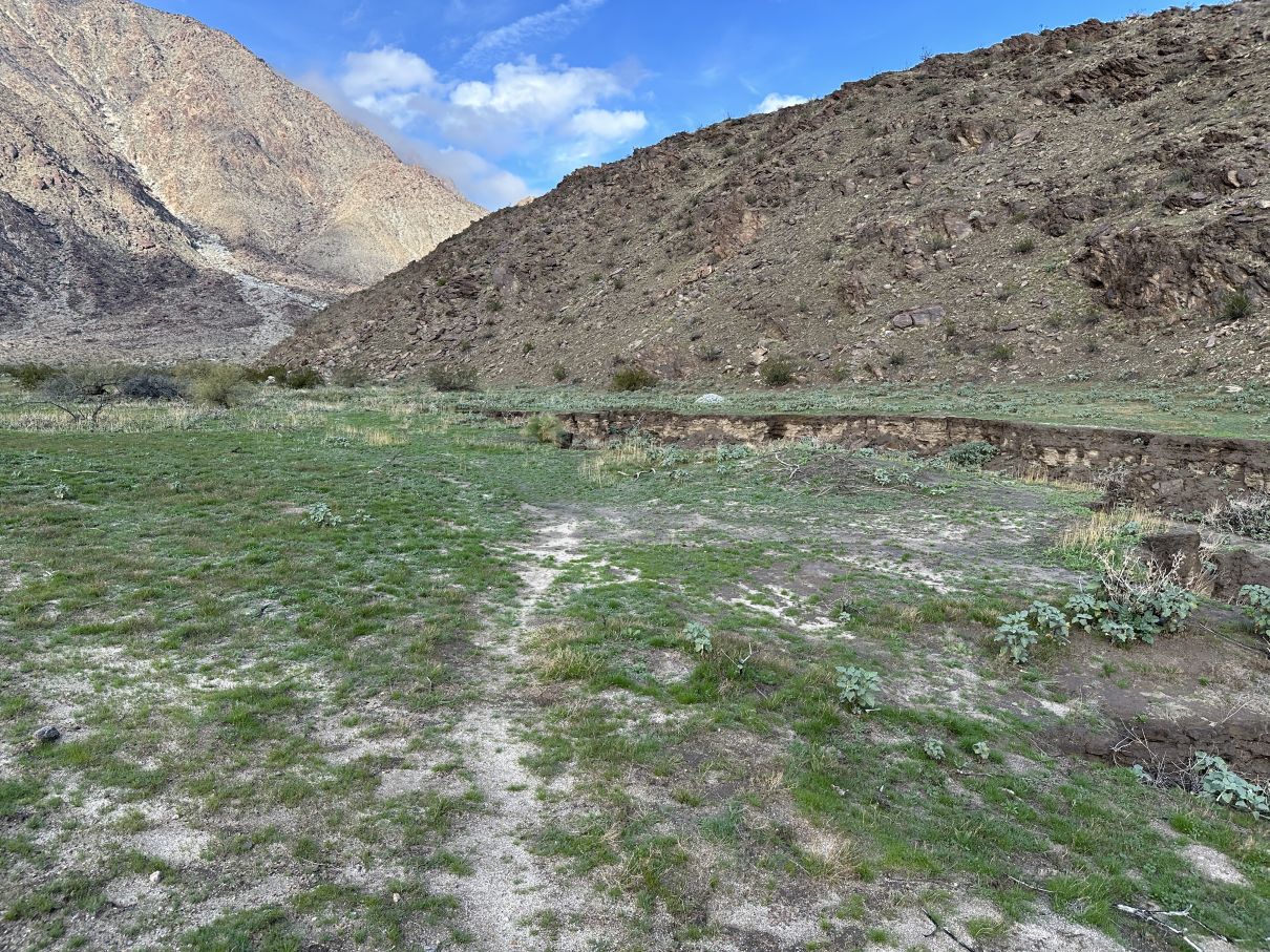
As you might imagine, deposition and erosion from the drainage in The Cove makes the topography interesting on a smaller scale as well. Fig. 5 shows some of the drainage channels from the mountainous areas above The Cove, as well as the main channels of the North Channel. The underlying map is the Google Earth image from 22 October 2023, after rain in the preceding months caused green patches of plants visible from space, showing where the water ponded.

Fig. 5. Google Earth image from 22 October 2023, showing areas of green from plants that grew where water ponded from rain in the preceding months; some of the channels of the North Channel (in white) and some of the drainage channels from the mountains surrounding The Cove (various other colors). See also a Google Earth aerial view from 2000 feet above the BPC Campground area.
Water from all of the drainages traced with lines shown in Fig. 5 flows into the green areas. Water ponds in three separate shallow areas, that are separated by very low ridges from deposition by Borrego Palm Canyon creek. The current nick point of the North Channel has already eaten into a portion of the lowest ponding area; see Fig. 4 for a closer view of that, as well as Tom's photo from 26 January 2016 showing the green area and the nick point. So that lowermost green area is soon to be historical only.
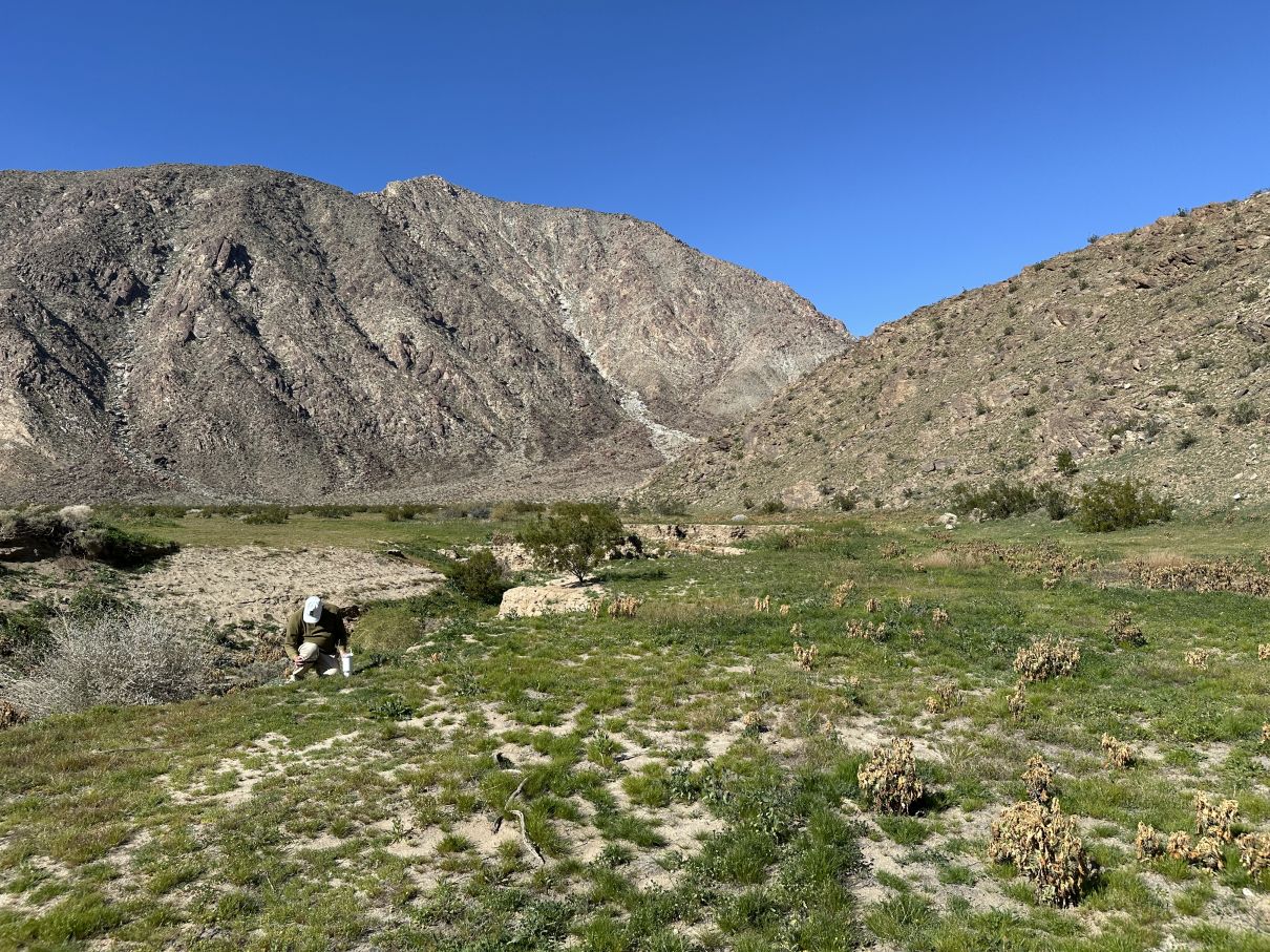
It is interesting that the North Channel and South Channel originate from a single location immediately north of the first BPC Creek crossing on the BPC Trail! See Tom's photo of the crossing of the BPC Trail as of 2 January 2026, showing the trail approaching the crossing on the right. The junction of the channels is just ~100 feet downstream. Fig. 6 shows the junction and the dry south channel immediately downstream.
| 
|
| Fig. 6. View looking down the South Channel. Left: View from the North Channel, showing a rise of about three feet before the South Channel continues downstream. Right: View from 150 feet (50 m) downstream from the junction with the North Channel, showing a completely dry South Channel.
Photos by Tom Chester. Click on the pictures for larger versions. | |
The south channel is just ~3 feet (~1 m) higher than the north channel at the junction. So if the water level in the north channel is 3 feet deep, some of it will start to trickle into the south channel.
A 3 foot rise is nothing compared to a 10 foot flood event, so flood events can reset which channel is the active channel. Flood events both erode and deposit mud, sand, and boulders, depending on the location in the water flow, and the water flow can stop at any point in the stream, depending on the volume of water coming down Borrego Palm Canyon. So which channel is active can easily change with a single flood event.
Table 1 records which channel has been active at various dates. If you have records of when a given channel had water in it, please let us know and we'll add it to the Table.
Table 1. Dates of observed water flow in BPC Channels
| Date | North | South | Notes |
|---|---|---|---|
| 10/5/1995 | X | Google Earth image | |
| 9/15/2003 | X | X | Google Earth image |
| 2/29/2004 | X | Google Earth image | |
| 6/11/2005 | X | Google Earth image | |
| 2/21/2006 | X | Google Earth image | |
| 4/15/2020 | X | Google Earth image | |
| 3/17/2023 | X | Tom Chester, Don Rideout. Water flowing 1.3 miles below junction. | |
| 1/2/2026 | X | n | Tom Chester, Tom White. Water flowing 0.6 miles below junction. |
|
X = water observed to be present in that channel
| |||
Tom Chester thanks Tom White for assistance with the 2 January 2026 fieldwork.