
|
Geographic Distribution Maps | 
|
| Fig. 1. Left: Cheilanthes_viscida, sticky lipfern from Smuggler Canyon on 27 December 2013. Note the shiny appearance of some of the leaves caused by the sticky goo on them reflecting the flash used for this photo.
Right: Cheilanthes covillei, beady lipfern, photo from Bitter Creek, on 15 April 2012. Note the beaded appearance of the upper surface, and how it differs between younger and older leaves. Note also the white scales visible poking through from the lower surface, looking a bit like white hairs. The reddish object with long awns is an unrelated grass seed. Photos by Kate Harper. Click on the pictures for larger versions. | ||
There are eight species in the Pteridaceae, Brake Family, plus one species which is a hybrid between two of them, found in the Borrego Desert below 3000 feet elevation:
- Adiantum capillus-veneris, maidenhair fern
- Cheilanthes covillei, beady lipfern
- Cheilanthes covillei X C. parryi = Cheilanthes Xparishii, teensy lipfern
- Cheilanthes parryi, woolly lipfern
- Cheilanthes viscida, sticky lipfern
- Notholaena californica ssp. californica, California cloak fern
- Pellaea andromedifolia, coffee fern
- Pellaea mucronata var. mucronata, bird's-foot fern
- Pentagramma triangularis ssp. triangularis, goldback fern
The geographic distribution maps for each of these species, except for Cheilanthes covillei X C. parryi, are given below, in alphabetical order by scientific name. No map is presented for Cheilanthes covillei X C. parryi since we have not yet found it. There is only a single voucher event, of two duplicate vouchers, from Sentenac Canyon, collected in February 1964. This hybrid could be found wherever the two parent species come into close contact.
Pentagramma triangularis ssp. rebmanii, Rebman's silverback fern, is found at 3180 feet elevation on the PCT south of Scissors Crossing toward Granite Mountain, just outside the boundaries of the Borrego Desert used here.
Cheilanthes clevelandii, scaly lipfern, is found at higher elevations in the mountains to the west of the Borrego Desert.
There is a single voucher of Cheilanthes wootonii, Wooton's lace fern, from the Borrego Desert, but that voucher is almost surely misdetermined. There is also a single voucher of Pellaea truncata, cliff brake, from the Borrego Desert, but that voucher is also almost surely misdetermined.
See Geographic Distribution Maps for an introduction to these geographic distribution maps, and maps of all the points for all species in our database. That coverage map, and the map for a given species, allow one to know where we have surveyed and have not found that species.
These maps were made from our incompletely-digitized records, as of 29 November 2015. Click on the maps for slightly-larger versions.
The number of GPS points in our records is given for each species. See Geographic Distribution Maps for a number of things to be kept in mind about these points.
The elevation ranges in our records for the Borrego Desert area are given for each species. If the records show a fairly-continuous distribution in elevation, a single range is given. If the lowest elevation records, and/or the highest elevation records, do not show a fairly-continuous distribution, those outlying records are given in parentheses, so that one knows the elevations at which a given species is commonly seen.
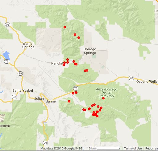
| Adiantum capillus-veneris 1 record 1800 feet | Cheilanthes covillei 56 records (1395) 1960 to 4100 (4495) feet |
|---|---|

| 
|
| Cheilanthes covillei X C. parryi = Cheilanthes Xparishii no records | Cheilanthes parryi 60 records 835 to 3955 (4620) feet |
| (Intentionally blank; no records) | 
|
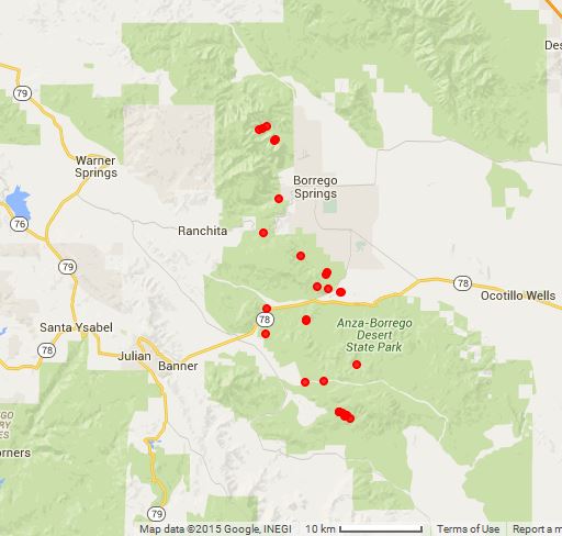
| Cheilanthes viscida 32 records 1520 to 3585 feet | Notholaena californica ssp. californica 31 records 1160 to 3580 feet |

| 
|
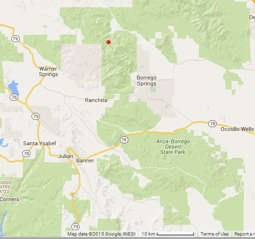
| Pellaea andromedifolia 1 record 2015 feet | Pellaea mucronata var. mucronata 41 records 2200 to 4120 (5245) feet |
| 
|
| Pentagramma triangularis 3 records 3180 to 4085 feet | (intentionally blank) |

| (intentionally blank) |
Go to:
Copyright © 2015 by Tom Chester, Mike Crouse, Kate Harper, Adrienne Ballwey, and James Dillane.
Commercial rights reserved. Permission is granted to reproduce any or all of this page for individual or non-profit institutional internal use as long as credit is given to us at this source:
http://tchester.org/bd/species/pteridaceae/geographic_distribution_maps.html
Comments and feedback: Tom Chester
Updated 30 November 2015