A2 Highway 94 to Lake Morena | ||
| Fig. 1. (Plant photographs to be supplied) | ||
| Segment Start | Segment End | Segment Length | Elevation (feet) | ||
|---|---|---|---|---|---|
| Min | Max | Range | |||
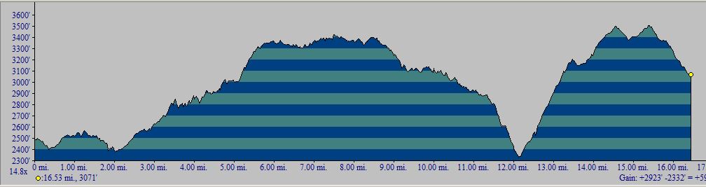
| Highway 94, 2480 feet | Lake Morena, 3070 feet | 17.5 miles | 2315 | 3500 | 1185 |
|
This section covers mile 2.3 to mile 20 from the Mexican Border (see Accuracy of Reported Trail Mileages).
Topo! gives a one-way distance of 16.5 miles, almost surely an underestimate due to the tight switchbacks and zigzags. The PCT Data Book gives 17.9 miles as the length, but it uses a trail longer by ~0.35 miles near the South Boundary Road than that given by the GPS points from Half Mile. We went with 17.5 miles for the length to make sure we did not underestimate the mileage. The one-way hike from south to north has a total elevation gain of 2500 feet; see the profile below. The one-way hike from north to south has a total elevation gain of 1950 feet; see the profile below. | |||||
Introduction
Survey Dates
The Plant Checklists
Introduction
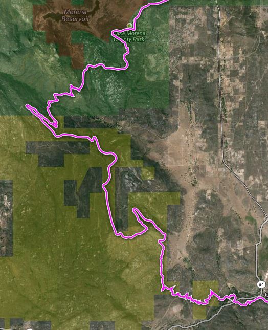
This section of the trail begins in the Southern Foothills Plant Community, and quickly enters the Southern Mountains, as defined by the San Diego County Plant Atlas. The plant community is almost entirely chaparral throughout.
This section of the trail winds though chaparral, some areas which have been burned a few years ago. The trail crosses two small creeks with perennial water, which is interesting, since the main drainage of Hauser canyon was dry. Hauser canyon, the significant geographic feature of this hike, takes 5 miles to cross to the other side. The large, magenta pea, called The Pride of California, aka Campo Pea, continues to be found in this section, as well as Salvia munzii, another unusual plant found only in this section.
| 
|
Fig. 2. Left: Trail Map for the PCT Section A2 from Highway 94 to Lake Morena, from USDA Forest Service Interactive Map. Right: Elevation profile from Highway 94 to Lake Morena (south to north). Click on the pictures for larger versions.
Survey Dates
The entire section was surveyed on 4/28/2013, at peak bloom, with a partial survey done on the four miles south of Lake Morena on 3/13/13, when most plants were dormant. Both surveys were done by RT and Shaun Hawke. 186 species were observed on 4/28/13, with an additional six species found only on 3/13/13. On 4/28/13, the area was in peak bloom and also was one of the best areas for this dry year in southern California.
The Plant Checklists
There are four different versions of the Plant Checklists, which differ depending on:
- whether only species observed in the immediate vicinity of the trail are included, or whether species are also included from the larger area surrounding the trail, some of which might be found on the trail in future surveys;
- whether the list is presented in trail order, or in plant family order; and
- whether thumbnail photographs are included with the list or instead, links are provided to Calphotos pix and the Jepson Manual eflora.
The lists are:
- Illustrated Family Order List from Calflora, with two thumbnail pictures for every species found on the trail (188 taxa). Note the checkbox at right that allows a sort of the list in family order instead of scientific name order, or a sort by bloom start month. Check Show photo service links and then click on Display to get links to all Calphotos et al pictures.
- Species in Order Along the Trail, from Highway 94 to Lake Morena, with links to Jepson Manual Treatment and Calphotos (192 taxa)
- Species Seen on or near the Trail in a Family Order List, with links to Jepson Manual Treatment and Calphotos (not yet available; these species are included in the next checklist)
- Species Seen on or near the Trail, along with species vouchered from this general area, in a Family Order List, with links to Jepson Manual Treatment and Calphotos (328 taxa)
Separate condensed print versions of just the checklist names are available for all except for the Calflora thumbnail picture version, as a link on each of those pages.
The vouchered species were obtained from a search of the Consortium of California Herbaria on 13 May 2013, for georeferenced vouchers with locations between 32.60 and 32.68° N. latitude and -116.56 and -116.48° E. longitude. The search yielded 669 vouchers of 280 taxa. One additional voucher was tossed since it was georeferenced incorrectly.