A3 Lake Morena to Highway 80 (Boulder Creek Campground) | ||
| Fig. 1. (Plant photographs to be supplied) | ||
| Segment Start | Segment End | Segment Length | Elevation (feet) | ||
|---|---|---|---|---|---|
| Min | Max | Range | |||
| Lake Morena, 3070 feet | Highway 80 (Boulder Creek Campground) | 6.3 miles | 3040 | 3460 | 420 |
|
This section covers mile 20 to mile 26 from the Mexican Border (see notes on accuracy of mileages).
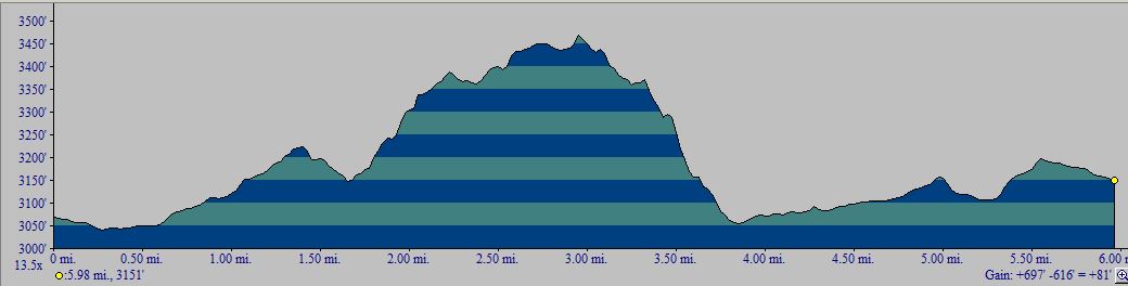
Topo! gives 6.0 miles for this segment; the PCT Data Book gives 6.3 miles. We went with 6.3 miles. The one-way hike from south to north has a total elevation gain of 570 feet; see the profile below. The one-way hike from north to south has a total elevation gain of 520 feet; see the profile below. A round-trip hike of this section is 12 miles, with an elevation gain and loss of 1100 feet. | |||||
Introduction
Survey Dates
The Plant Checklists
Introduction
This section of the trail is in the Southern Mountains Plant Community, as defined by the San Diego County Plant Atlas. The plant community is mostly chaparral, with some areas of grassland and oak woodlands.
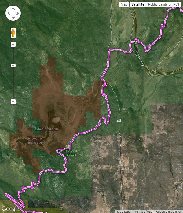
Section A3 starts out on the streets of the town of Morena Lake with the campground, site of the annual PCT kick-off, on the left side of the street. The trail leaves the pavement in short order and skirts the edge of Lake Morena. It then ascends a ridge instead of continuing to follow Kitchen Creek drainage, but the ridge top provides better views of the landscape. Ceanothus was in full bloom on 4/28/2013, as well as Peony, with the most individual plants I have ever seen. After ~4 miles, you drop down off the ridge to cross the Kitchen Creek drainage under Highway S1. The trail parallels this highway for a bit then turns away from it, crossing oak woodland and grassland. There are some thick stands of sagebrush, which are probably unnatural due to grazing and suppressed fire cycle.
| 
|
Fig. 2. Left: Trail Map for the PCT Section A3 from Lake Morena to Highway 80 (Boulder Creek Campground), from USDA Forest Service Interactive Map. Right: Elevation profile from Lake Morena to Highway 80 (south to north). Click on the pictures for larger versions.
Survey Dates
Surveyed 4/7/2013 by RT Hawke. 140 species were observed. A number of early season plants were in bloom. 13 additional species were vouchered from or near the trail that were not seen in the 4/7/2013 survey.
The Plant Checklists
There are four different versions of the Plant Checklists, which differ depending on:
- whether only species observed in the immediate vicinity of the trail are included, or whether species are also included from the larger area surrounding the trail, some of which might be found on the trail in future surveys;
- whether the list is presented in trail order, or in plant family order; and
- whether thumbnail photographs are included with the list or instead, links are provided to Calphotos pix and the Jepson Manual eflora.
The lists are:
- Illustrated Family Order List from Calflora, with two thumbnail pictures for every species found on the trail (153 taxa). Note the checkbox at right that allows a sort of the list in family order instead of scientific name order, or a sort by bloom start month. Check Show photo service links and then click on Display to get links to all Calphotos et al pictures.
- Species in Order Along the Trail, from Lake Morena to Highway 80 (Boulder Creek Campground), with links to Jepson Manual Treatment and Calphotos (153 taxa)
- Species Seen on or near the Trail in a Family Order List, with links to Jepson Manual Treatment and Calphotos (not yet available; these species are included in the next checklist)
- Species Seen on or near the Trail, along with species vouchered from this general area, in a Family Order List, with links to Jepson Manual Treatment and Calphotos (295 taxa)
Separate condensed print versions of just the checklist names are available for all except for the Calflora thumbnail picture version, as a link on each of those pages.
The vouchered species were obtained from a search of the Consortium of California Herbaria on 2 May 2013, for georeferenced vouchers with locations between 32.68 and 32.77° N. latitude and -116.53 and -116.43° E. longitude. The search yielded 632 vouchers of 261 taxa. Two additional vouchers were tossed since they were georeferenced incorrectly.