Natural bridges and arches are openings through a rock mass; they can be formed in a number of ways. The largest ones known are formed by the cutting action of streams.
from World Atlas Of Geomorphic Features by Rodman E. Snead, 1980, Krieger: Huntington, NY.
Natural bridges and arches are relatively rare. Snead plots only 19 locations containing "large" natural bridges and arches, with 12 locations within the Colorado Plateau, one in Death Valley, one in Texas, and the other five in the East.
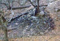
Imagine our surprise when we learned that there was one in the San Gabriels. This one is unique not only for its rarity in Southern California, but also for its composition: it is made nearly entirely out of dirt and rock!
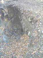
Robinson says "flowing water from one of the springs has formed a natural bridge" (TOTA98, p. 101). However, there is unfortunately some question as to just how "natural" this particular "natural bridge" actually is, which is why we have used quotes around that term. It may be that the bridge is entirely natural, but it may be that an existing spring was "tunneled" to try to improve its output, after which the same natural processes formed the bridge. See below.
In any case, this is still a pretty spectacular feature.
Tom surmises: This natural bridge of course won't qualify as large. But it is still very spectacular, especially given its location where natural bridges are rare.
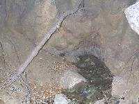
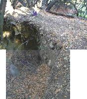
If the bridge is entirely natural, this one surely formed akin to the large bridges in the west - the spring was in a weak area of rock, and the water flow eroded back along the weak rock creating a tunnel. One possible scenario for the formation of the natural bridge is that back when the water table was higher, the spring eroded to the uphill side of the bridge. At that point, the erosion met the base of the alluvium above the bridge. Relatively rapidly, the alluvium collapsed into the tunnel, creating the pit above the bridge and thus delineating the bridge. Then the water table lowered, the spring went to lower elevation, so there is no spring above the tunnel any more. Continued erosion above the upper tunnel entrance created the large pit above it, including the sloped walls above the pit, created by surface water, and the vertical wall at the bridge from lack of any significant water source for continued erosion.
See the illustrations in Model For Formation Of Natural Bridge for a more complete description of this scenario.
If the bridge is not completely natural, what probably happened was this. (The information in this paragraph is from Jane.) Springs were apparently sometimes "tunneled" to improve the output of the spring, albeit usually only temporarily. (See, for example, Glendora by Donald Pflueger, Chapter 8: Liquid Gold - Glendora Style,
Claremont, CA: Sauders Press, 1951, p. 134.) The springs were claimed by the Deer Park Development Company, and in 1895 tunnel No. 3 located at Twin Springs was built. (History of Monrovia, John L. Wiley, 1927,
Chapter XIII: Monrovia's Water Quest, p. 283.)
It is possible that this spring was tunneled, with the result that the tunnelers broke into the alluvium above the spring. Once that occurred, erosion would proceed just as if nature had eroded weak rock to that point, and the pit formed naturally, just as in the scenario above.
So, the "Natural Bridge" is either completely natural, which is unlikely given the evidence for "tunnel No. 3", or partially natural. In any case, enjoy it for what it is, a unique feature of the San Gabriel Mountains.
We welcome any further elucidation on the formation and location of any similar features in the San Gabriel Mountains.
All photographs were taken by Tom Chester, December 3, 1999, Twin Springs Canyon, San Gabriel Mountains, California.


