80-2 Mt. Lewis from Dawson Saddle Map
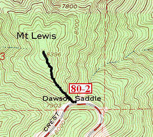
Section of the 1972 photorevision of the Crystal Lake Quadrangle
(Hike 80-2 is the black line)
Return to:
80-2 Mt. Lewis from Dawson Saddle
Hikes in the SGM: Mt. Islip Region
Copyright © 1999-2003 by Jane Strong and Tom Chester
Permission is freely granted to reproduce any or all of this page as long as credit is given to us at this source:
http://tchester.org/trails/maps/mt_islip/80-2map.html
Comments and feedback: Jane Strong | Tom Chester
Page created September 9, 1999 (urls updated 7 April 2003)