
Section of the 1972 photorevision of the Waterman Mountain Quadrangle
Click on the map for a larger and sharper image
Section with some of the 1995 revisions and additional hikes
Click on the map for a larger and sharper image
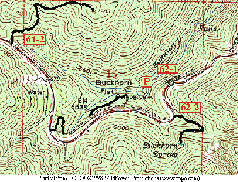
Section with some of the 1995 revisions and additional hikes
Click on the map for a larger and sharper image
Changes and additions between editions drawn as heavy black lines:
- 61-2 The Buckhorn Peak Trail
- The "guard station" was torn down and removed several years ago
- The entrance to the campground has been changed
- The campground access road is one way from west to east
- Not all the campground roads are drawn in
- The P is the Burkhart Trail parking lot where Hike 62-1 starts
- 62-2 The Buckhorn Spring Trail
See also: 61-2 Buckhorn Peak 62-1 Buckhorn Falls 62-2 Buckhorn Spring Return to: Hikes in the SGM: Mt. Islip Region