Overview
Road Parameters
Road Description
Hikes Using This Road
Links To Further Information
Overview The Sawpit Canyon Fire Road leads from Monrovia Canyon Park in the Monrovia foothills of the San Gabriel Mountains (SGM) to White Saddle between Monrovia Peak and Mt. Bliss.
Monrovia Canyon Park considers most of this road to be part of Ben Overturff Trail, but we treat Sawpit Canyon Fire Road as a distinct hiking route, as does Robinson.
The road is also called Monrovia Canyon Road by the USGS, and Monrovia Canyon Truck Trail by the Thomas Brothers L.A. Map (see below). Robinson and Monrovia Canyon Park call it Sawpit Canyon Fire Road, a more appropriate name since the road follows Sawpit Canyon and no part of the road is in Monrovia Canyon.
The Sawpit Canyon Fire Road has many attractions:
- Good views of:
- 150' high Sawpit Dam
- Beautiful Sawpit Canyon
- canyons filled with bigleaf maple and sycamore
- Narrow rocky recesses with possible seasonal waterfalls
- Exploration of the lower slopes of Monrovia Peak.
- A large area of Spanish Broom providing a delightful visual and olfactory pathway in Spring.
- The Sawpit-Clamshell Fault where the 1991 Sierra Madre Earthquake was centered.
The detractions are minimal: you are hardly ever out of sight of the works of man--fire roads, power lines, non-native trees and weeds, and the views are mostly restricted to those within Sawpit Canyon and the surrounding ridges.
Road Parameters Maps: The road is shown as Monrovia Canyon Road on the USGS 7.5' x 7.5' Azusa Quadrangle, 1972 revision, and Monrovia Canyon Truck Trail on the Thomas Brothers L.A. County Street Guide, 2000 edition, map 507. It is shown in part on the 1993 and later printings of John Robinson's Map for TOTA.
Season: All year.
Roadhead and directions to roadhead: The road begins at the lower end of Monrovia Canyon Park. From the entrance kiosk at the Park, follow the trail or road 0.25 miles to the first right hand turn. This is Canyon Park Junction of the Sawpit Canyon Fire Road, which has a map of the Overturff Trail and the Fire Road. The road ends at White Saddle between Monrovia Peak and Mt. Bliss. White Saddle can be accessed via the Van Tassel Fire Road from Duarte or Azusa or via Upper Clamshell Road from the Rincon - Red Box Truck Trail.
The road is closed on Tuesdays and Wednesdays when the Monrovia Police Department uses the shooting range on the road. Access via parking at Monrovia Canyon Park costs two dollars, and the gate at the Park is only open from 8:00 am to 5:00 pm with "no exceptions". Access via the Mt. Bliss and Van Tassel Fire Roads is not time-restricted.
Length: 5.0 miles according to Topo! measurements, verified by Tom's pedometer reading to Deer Park Junction.
Elevation Changes: Canyon Park Junction is at ~1,140' and White Saddle is at ~3,220'. Since the road has no elevation decreases on the way up, the total gain is thus ~2,080' on the Road.
Users: The Fire Road is available to all non-motorized users. Although the road is gated at Canyon Park Junction, users of the Boy Scout Camp up the road have keys to the gate, and hence there is infrequent vehicle traffic in the first mile. Another locked gate at Overturff Junction eliminates this traffic beyond that point.
Road Condition: The road is in excellent shape.
Road Maintenance: Probably by bulldozer.
History: from History of Monrovia, Chapter II, The Coming of the Spaniards, p. 33, by John L. Wiley, 1927, Press of Pasadena Star-News: Pasadena, California:
Tradition closely associates the construction of the San Gabriel Mission with the Monrovia Canyon, it being generally claimed that much of the timber and rock used in construction by the Mission Fathers was taken from this canyon. Sawpit Canyon, as it was then known, was so-called because of a large pit below Emerson flats where one sawyer would stand and assist another one standing on the surface to operate a large saw. In this manner the big logs were sawed into lumber of usable size and dimension.For more historical information, see Ben Overturff Trail.
Road Description The beginning of the road at Canyon Park Junction is a delightful place at the intersection of the streams from Monrovia Canyon and Sawpit Canyon. A surprising amount of water must run here year-round, judging from the flow in December 1999 after nearly two years of very little rainfall, none of which came from releases from Sawpit Dam.
The road samples many streams with perennial water. Streams are shaded by deciduous trees, tall white alders and bigleaf maples, mixed with evergreen canyon and coastal live oaks. Hanging gardens of ferns and mosses adorn many of the cool north-facing rocks.
The map at the beginning of the road shows the path of the road and gives mileages to a few points. The road is paved to somewhere beyond the top of the Dam. Stay right at the two intersections before the top of the Dam.
The road is very steep to the top of impressive Sawpit Dam at 0.40 miles. In December 1999, no water was retained behind it due to a lot of work being done on the Dam. A sign lower down the canyon mentioned creating a self-cleaning spillway, and the dam now has a U-shape cut into it about halfway down its face. Several stairways are being built there.
Look behind the water tank at mile 0.65 to see a seasonal waterfall (it may contain water only when it is raining.)
From this point and for some distance beyond on the road, when you face north, you can see Sawpit Canyon running northeast to southwest in front of you, the location of Monrovia Canyon running south to your left and see the maples in Maple Canyon running south to your right. The ridge that separates Big Santa Anita Canyon from Monrovia Canyon is on the skyline to the west. To the east, the ridge connects Mt. Bliss with Monrovia Peak. Most of the time you are too low to see Mt. Bliss.
The surrounding sunny slopes are an intergrade between coastal sage scrub and soft chaparral. Typical and abundant, perennial plants are toyon, poison oak, orange bush monkeyflower, white sage, California buckwheat, laurel sumac, chamise, yucca, scrub oak, California fuchsia, California sagebrush and chaparral whitethorn.
The entrance to Trask Boy Scout Reservation is on the left at 0.95 mile, and you continue right, viewing the Boy Scout Camp, with swimming pool and buildings on your left.
Overturff Junction is at 1.20 miles, marked by two stone pillars on your left with another map. The road has a locked gate on your right to keep out cars beyond this point.
The junction of the stream from Vassar Canyon with the stream from Sawpit Canyon is just ahead, and the road briefly follows the Vassar Canyon stream until you cross the Vassar stream (only a wet spot in December 1999) at 1.70 miles.
The road turns north after crossing Vassar Canyon, and the view dead ahead is of Deer Park and the tree-covered slopes below it.
The Monrovia Police Firing Range is 0.5 mile ahead at 2.20 miles, and the road near here is surrounded by Spanish broom. This spot must be heavenly when the broom is blooming!
Just ahead is Twin Springs Junction at 2.75 miles, another place to look at the provided map and join the Overturff Trail if desired.
Another 0.5 mile leads to Deer Park Junction, with its handicapped-accessible bathroom.
The road continues for 1.5 miles to White Saddle, but we haven't hiked on this part of the road. Tom has been to White Saddle, which is named for the very white rocks in that location.
Detailed Trip Log
This log gives the mileage and time to features along the road from Canyon Park Junction, along with their altitude. The mileage is from Tom's pedometer reading, which agrees well with the mileages derived from Topo!. The mileages are probably accurate only to 0.1 mile, but are given to 0.01 mile to prevent adding rounding errors.
Times are from the start of the hike. Your times may be shorter since Jane and Tom spent a lot of time looking at the plants, topographic features and views along the way. No times are given beyond Overturff Junction, since we only have hiked down the road from Deer Park Junction to there. The altitudes are from the topo map, for features that could clearly be identified there, and from Tom's adjusted altimeter reading for other locations.
# Mileage Time From Start Altitude Comments 1 0.00 0:00 1140 Canyon Park Jct of the beginning of Sawpit Canyon Fire Road (2N30). Right. Sign with trail map. Sign: "1 1/4 miles to Overtuff Jct., 3 1/4 to Deer Park Cabin site, 2 1/2 to Twin Springs Jct." 2 0.05 0:03 1150 Jct. gated dirt road on left. Stay right. 3 0.42 0:16 1350 Sign: Camp Trask Scout Reservation on left. Stay right. 4 0.65 0:26 1460 Seasonal waterfall behind water tank. 5 0.95 0:37 1600 Trask entrance on left. Stay right. 6 1.20 0:50 1680 Overtuff Jct., Jct. Ben Overtuff Trail. Left. Locked gate on fire road on right. Sign: "2 miles to Old Cabin site, 1 1/4 mile to Canyon Park, 1 1/2 to Twin Springs Jct., 3 1/2 to White Saddle." 7 2.52 2250 Monrovia Police Firing Range. Lots of Spanish broom here! 8 2.74 2360 "Twin Springs Jct" to Overtuff Trail. Continue on road. Sign: "1/2 mile to Cabin site, 1 1/2 mile to Overtuff Jct., 2 3/4 mile to Canyon Park Trailhead, 2 mile to White Saddle". 9 3.22 2560 "Deer Park Jct", with handicapped access bathroom.
Hikes Using This Road When available, the date of the information is given in parentheses for each link.
48-3 Monrovia Canyon Park to Sawpit Canyon, Deer Park, T. Chester and J. Strong (03Dec99)
JPL's Mountain Bike Ride to White Saddle (14Mar98)
Links To Further Information
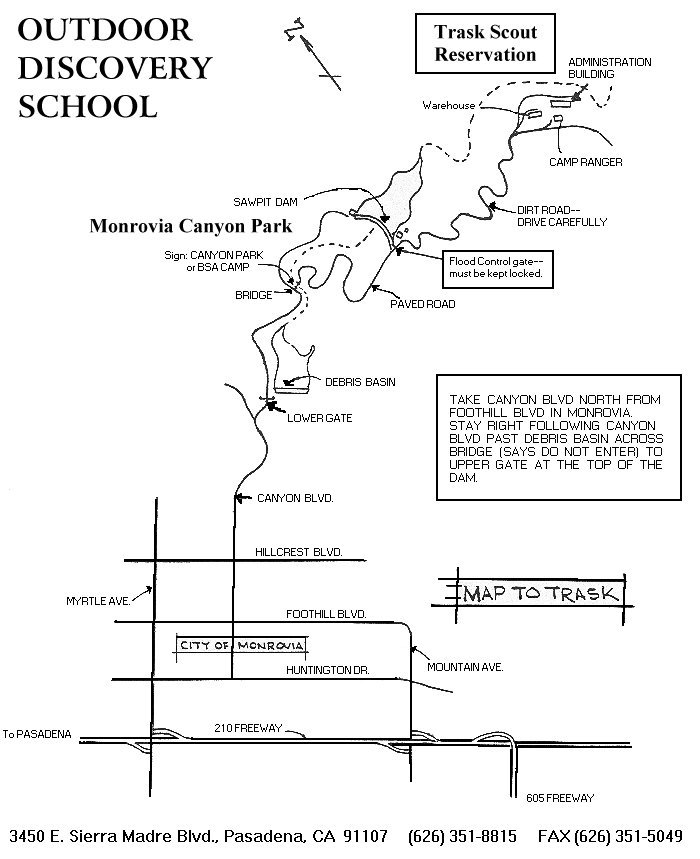
- Trask Scout Reservation Outdoor Discovery School
- Excellent Map to Trask Scout Reservation with directions from freeway
- Geologic Studies of Deeply Exhumed Faults of the San Andreas System, Southern California Investigation of the Sawpit-Clamshell Fault with report on 1991 Sierra Madre Earthquake and great maps!
- SCEC's Clamshell-Sawpit Earthquake Fault
- Sawpit Dam information with photo
- More about Sawpit Dam
Go to:
Copyright © 1999 by Tom Chester and Jane Strong.
Permission is freely granted to reproduce any or all of this page as long as credit is given to us at this source:
http://tchester.org/sgm/trails/sawpit.html
Comments and feedback: Tom Chester | Jane Strong
Updated 10 December 1999.