Stream Bank Deposits in Round Valley Meadow, August 2013, San Jacinto Mountain
 |  |
| Fig. 1. Click on the pictures for larger versions.
Left: View downstream on 8 August 2013 of one of the stream bank deposits left by runoff from a thunderstorm on 21 July 2013. The water flowed almost freely in the lower area on the right covered by the glaucous leaves of Carex nebrascensis, with the left edge of the water flow depositing the debris on this left bank. The deposits are on the higher ground to the left, marked by the green leaves of Carex senta to the left of the debris. The debris is about one foot thick. Right: Cartoon View of water flow on 21 July 2013 superimposed on Google Earth View of Round Valley Meadow using 16 September 2011 imagery. The water flow from the upstream drainage is shown in blue above Round Valley Meadow, where it was confined to the canyon bottom. The sheeting flow of the water across the upper meadow is shown by the area hatched with diagonal red lines. The slightly-higher ground with abundant trees stopped the sheeting flow and broke it up into a series of gentler flows in the middle meadow. Those gentler flows followed the drainages in the meadow, depositing debris at the edges of each channel, shown as the gray lines. | |
Introduction
Round Valley Meadow is a nearly-pristine area at 9000 feet at San Jacinto Mountain that was in danger of being drained completely by headward erosion of a major gully at its lower outlet. The water table in the lower parts of the meadow was already significantly lowered by that gully, and it was only a matter of time before the water table was lowered in the entire meadow. The gully was almost surely caused by a period of cattle grazing prior to about 1930. In September 2010, the gully was filled and replanted, to restore the natural drainage, under the direction of two of the authors of this page, Ken Kietzer and Doug Rischbieter.
The site recovery has been monitored every year since then, and it has been heartening to see the restoration work surviving without major damage, and to see the meadow sedges in the lowermost meadow responding to the increased moisture.
As part of the monitoring work in August 2013, Ken invited the other two authors of this page, Tom Chester and Adrienne Ballwey, to do a botanical survey of the meadow, following up previous surveys done by Tom Chester and Dave Stith.
All of us were very surprised to see extensive stream bank deposits in the meadow from the thunderstorm event of 21 July 2013 that helped to put out the Mountain Fire. This page shows pictures of those deposits, and gives a possible explanation of the sequence of events that led to those deposits.
Note that these deposits were normal stream bank deposits; there was no debris flow here, which is a liquefied landslide, which might well have happened in the Mountain Fire burn area from this same thunderstorm event. No part of the watershed here burned in the Mountain Fire. The debris deposits here were composed of normal duff found above the soil in the forest floor.
Such deposits probably account at least in part for the hummocky nature of the terrain in Round Valley Meadow. The hummocky terrain was noted and discussed by Cooper and Wolf in their 2009 study and analysis of Round Valley Meadow prepared for the California Department of Parks and Recreation. Cooper and Wolf speculated these hummocks were remnants of a past higher meadow soil level, and that they resulted from severe disturbance and resulting erosion during the 20th century. While there may indeed have been extra erosion in the last century, this July 2013 event clearly shows that the hummocks are at least in part a normal depositional event.
Topography of Round Valley Meadow and the 21 July 2013 Water Flow
Fig. 2 shows a Google Earth view of Round Valley Meadow looking west, and the drainage basin above it.

Click on the picture for a larger version.
Thunderstorms often deliver a lot of rainfall in a very short time, and the 21 July 2013 thunderstorm may have been enhanced by nucleation on the smoke particles from the plume of the Mountain Fire that was burning on the other side of the Wellman Divide Ridge at the time, as well as the moisture in the smoke plume as a result of the combustion. See:
- Pyrocumulonimbus clouds;
- "Smoke plumes can create more intense rainfall" summary and paper.
Fig. 2 shows a fairly extensive drainage basin above Round Valley Meadow that funnels into the main drainage in Upper Round Valley. The rain from the thunderstorm would quickly cause the water level to rise in that main drainage, which would be confined to the canyon bottom until the drainage opens up at Round Valley Meadow.
Fig. 3 shows a Google Earth view of Round Valley Meadow from above, with our reconstruction of the events from the 21 July 2013 thunderstorm:
Fig. 3. Our Cartoon View reconstruction of water flow on 21 July 2013 superimposed on Google Earth View of Round Valley Meadow using 16 September 2011 imagery. The water flow from the upstream drainage is shown in blue above Round Valley Meadow, where it was confined to the canyon bottom. The sheeting flow of the water across the upper meadow is shown by the area hatched with diagonal red lines. The slightly-higher ground with abundant trees stopped the sheeting flow and broke it up into a series of gentler flows in the middle meadow. Those gentler flows followed the drainages in the meadow, depositing debris at the edges of each channel, shown as the gray lines.
Click on the picture for a larger version.
Round Valley Meadow, except along its edges, consists almost entirely of two habitats: boggy areas dominated by Carex nebrascensis along with a handful of other soggy-area loving plants, and less-boggy areas composed almost entirely of Carex senta, with few or no accompanying species. Because C. senta has green leaves, and C. nebrascensis has glaucous (blue-green or gray-green leaves), those areas can be easily seen in an aerial or satellite view, such as the unmarked Google Image from Fig. 3. Some of the boggy areas are outlined in blue in this image.
Non-thunderstorm rainfall, spring and groundwater flows follow those low areas, going around the central area with trees. The view looking down the meadow from near its top shows a sandy area at the top of Round Valley Meadow, where the water usually seeps into the ground, to flow as groundwater and surface in the boggy areas surrounding the central area with trees. See also View of the sandy area after the flood event, looking along the water flow toward the central area with trees.
The water flow from an intense thunderstorm event behaves differently. That strong water flow will pick up all the debris in the bottom of the drainage and carry it along, cleaning out its channel. As the water spreads out below the canyon to which it had been confined, and the water velocity drops to the point where it can no longer move the sand, it will drop any sand it is carrying in that sandy area, or just below.
As always in sandy beds, some events will deposit sand, and some will erode sand, or do both in different parts of that sandy area. In this case, the water was still moving quickly enough when it entered the sandy area so that about six inches of sand was eroded in one spot near the head of the sandy area, exposing a buried water hose. The velocity of the water decreased enough a bit farther downstream to deposit its total load of sand, still in the sandy area, or immediately below, since no sand deposits were seen farther downstream.
Second, due to the large volume of water and its momentum from its rapid flow, it will keep rushing in a straight line, and run right into that higher ground with the trees. At this point, most of the remaining momentum of most of the 21 July flow was dissipated. The flow became gentler and was broken up into many substreams now following the lower-elevation parts of the meadow.
The water flow continued to carry the pine needles, pine cones, wood pieces, and small soil particles since those were bouyant, being carried along on the top of the water flow. These particles may not have even been wetted substantially, and remained hydrophobic as they were carried along on top of the flow.
At this point, the normal process of river bank levee building occurred, illustrated in Fig. 4, a diagram from Press and Siever, The Earth, due to the overflow beyond the edges of the lower-elevation parts of the meadow.
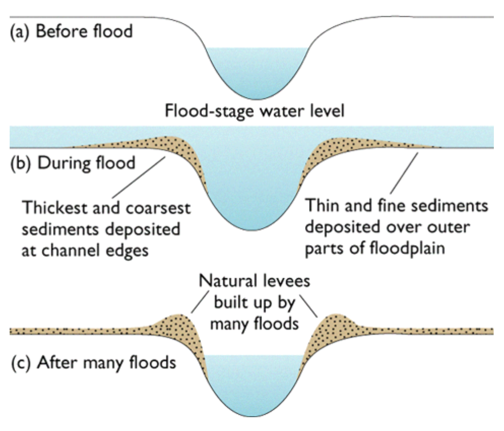
Fig. 4. "Natural levees are formed along the margins of the low flow channel whenever a river overflows its banks, usually during spring runoff." Figure from Should I Trust That Levee? by J. David Rogers, taken from Press and Siever, The Earth.
In this case, the "thickest and coarsest sediments" were the pine needles, pine cones, and wood pieces, seen as the prominent deposits along the channels in the meadow. We don't know if there was much fine sediment transported by the flood, nor if the water level ever exceeded where the coarse debris was deposited. It would be interesting to look for any fine sediment deposited farther away from the channel than the coarse debris.
Floods like this help build up the organic content of the meadow, although we do not know whether this is the dominant process in creating organic matter in the meadow, or whether the growth and decay of the meadow plants dominates.
Views of the deposits
Fig. 5 is a blow-up of the left-hand side of a panorama taken from the northwest edge of the meadow, showing the sediment deposits below the higher ground with abundant trees, at the extreme right in Fig. 5 and in the middle of the linked panorama.

Fig. 5. The low-elevation areas in the meadow below the higher ground with abundant trees are lined with the deposits from the flow at their edges. Click on the picture for a larger version.
We observed abundant deposits at the edges of the lower-elevation areas as well as at the upstream portion of higher-elevation islands surrounded by lower-elevation areas, as shown in this photograph.
A close-up view of one of the deposits shows that they are made mostly of lodgepole pine needles (two needles per cluster) and duff, the decomposed material made from pine needles found in the pine forest. Occasional lodgepole pine cones, typically 2-6 cm in each dimension, and pieces of decomposed tree trunks are also present. Most deposits were about one foot deep. The deposits were very airy and unconsolidated; stepping on them often resulted in compressing the debris by a factor of two or so, with the debris falling onto one's shoes.
There was only a single deposit of sand immediately below the meadow, produced by a small amount of erosion in one of the lowermost side channels in the meadow. This photograph of that channel shows debris deposits on the right, and erosion in the main channel where the water was funneled. The eroded area is the part of the channel without plants, with exposed gravel-sized rocks. The eroded sand was deposited in the main channel a bit downstream where it opened up, seen as the white sandy area just to the right of the top middle of the photograph.