General Information
Access
Hikes
Other Web Information
General Information Monrovia Canyon Park (1,080'-1,860') is a wilderness park in the city of Monrovia immediately south of the Angeles National Forest boundary. The park emphasizes nature, allowing only activities compatible with minimal interference to the wildlife in the Park such as hiking and picnicking.
The Park is open to the public Wednesday through Monday from 8:00 am to 5:00 pm. with a $5 parking fee. The entrance gate is closed at 5:00 pm, "no exceptions"! The park is closed to vehicles on Tuesdays to allow Outdoor Education Programs for school districts. The Ben Overturff Trail / Sawpit Canyon Fire Road is closed on Tuesdays and Wednesdays when the Monrovia Police Department conducts police training exercises and uses the shooting range.
The Park contains a Nature Center with displays of local wildlife and plant communities. There are four Picnic Areas that allow barbecuing only with your own charcoal. The Cabin and Fireman's Flat picnic areas are rented hourly or for day/night use for conferences, birthday parties or families. Sawpit Dam is located within the Park, and can be viewed from the Sawpit Canyon Fire Road.
Hiking is the other main activity, with three different trailheads for the popular Monrovia Falls hike. The hike is 1.5 miles roundtrip from the trailhead behind the Nature Center; 2 miles from the trailhead by the middle parking lot, and 3.4 miles from the trailhead by the Entrance Station.
The Sawpit Canyon Fire Road / Ben Overturff Trail loop is 7.2 miles roundtrip from the lower parking lot with 1,850' altitude gain. The roundtrip to Monrovia Peak is 12 miles with 5,000' elevation gain.
A recently-opened trail that will ultimately lead to Upper Clamshell Road begins at the Entrance Station and in 1999 is open to Vista Point, offering good views of Monrovia and Sawpit Canyon.
The phone number of the Park is 626-256-8282.
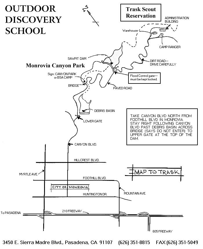
Access Map: San Gabriel River Region (MCP at the lower left edge of the map) shows the general location. Map to Trask Scout Reservation shows the main Park Road and the first mile of Sawpit Canyon Fire Road.
The Park is called Monrovia Mountain Park on the Azusa USGS 7.5' x 7.5' Map. Sawpit Canyon Road intersects the Park Road at (34.17409°, 117.98970°), at or near most of the trailheads.By Car: From I-210 take Myrtle Avenue north through the center of Monrovia. Turn right on Foothill Boulevard, then left on Canyon Boulevard which leads to Monrovia Canyon Park. There are three main parking areas, off the lower, middle and upper part of the park road. Parking Fee is two dollars.
By Trail: The only access to the Park via trail from elsewhere is Sawpit Canyon Fire Road.
Hikes Warning: This list does not get updated as often as the hikes listed in the region tables. Consult San Gabriel River Region Hikes for the latest listing.
When available, the date of the information is given in parentheses for each link.
Monrovia Canyon Falls, Dan Simpson (Apr05?)
48-3 Monrovia Canyon Park to Sawpit Canyon, Deer Park, T. Chester and J. Strong (03Dec99)
JPL's Mountain Bike Ride to White Saddle
Other Web Information
- Monrovia Canyon Park
- Canyon Park Improvement Project
- Life in L.A.'s Monrovia Canyon Park
- Geologic Studies of Deeply Exhumed Faults of the San Andreas System, Southern California Investigation of the Sawpit-Clamshell Fault with report on 1991 Sierra Madre Earthquake and great maps!
- SCEC's Clamshell-Sawpit Earthquake Fault
- Sawpit Dam information with photo
- More about Sawpit Dam
- The Foothills Wildlife Conservancy, including their Foothills of Monrovia and Wildlife Photos.
- Minutes of Monrovia City Council:
- Trail Grant Request to add 15 miles of Monrovia Peak/Clamshell Truck Trail (05Aug97)
- Trail Grant Request for Monrovia Peak/Clamshell Truck Trail (27Oct98)
Go to Field Guide to the San Gabriel Mountains: Places
Copyright © 1999-2005 by Jane Strong and Tom Chester
Permission is freely granted to reproduce any or all of this page as long as credit is given to us at this source:
http://tchester.org/sgm/places/monrovia_park.html
Comments and feedback: Jane Strong | Tom Chester
Updated 9 April 2005.